
Home Page |
MICHIGAN FORESTS FOREVER TEACHERS GUIDE
| LAND SURVEY |  |
Metes & Bounds
U.S. Public Land Survey
Legal Descriptions
How the Survey Works
Land Survey Measurement Units
When Europeans came to North America, they brought with them their sense of land ownership and property boundaries. It was an awesome challenge to take a wilderness and divide it up into ownership parcels. Most of the earliest descriptions used an archaic system called the "Rural Land Description". Its inadequacy can best be illustrated by the following excerpt in an 1812 record from Connecticut.
". . . after turning around in another direction, and by a sloping straight line to a certain heap of stone which is by pacing, just 18 rods and about one half a rod more from the stump of the big hemlock tree where Philo Blake killed the bear; . . ."
After land arguments became more litigious, lengths and directions were often (not always) provided from landmark to landmark. This subdivision of land is called "metes and bounds." "Metes" refers to measuring or "metering" property, and "bounds" refers to identifying boundaries. This was somewhat better, but when the landmarks died, disappeared, or changed re-establishing them was nearly impossible. This system exists today in the first 13 states and most of the land east of the Mississippi and south of the Ohio River, except for Alabama, Mississippi, and most of Florida. It became clear by the mid-1800s that this system would not be adequate for the disposal of land in a rapidly growing nation.
| Activity Suggestion Land Survey-Plat Books |
U.S. Public Land Survey
Modern land survey is based largely on proposals developed by Thomas Jefferson in 1784. What was to become Ohio was the guinea pig of land survey. Today, there are numerous survey systems in Ohio because the learning process was difficult. After a series of survey laws, in 1796 Congress finally arrived at the system that was used to open most of the new territory added to the United States. It is based on a series of rectangular surveys, adjusted for the curvature of the Earth; a rather heady project for the technology and infrastructure of the day.
The first surveys were done through contracts with the Government Land Office (GLO) for a newly opened up territory. Soon after a territory was ceded to the federal government by American Indian representatives (today, some of these treaties are questionable), the land needed to be surveyed before it could be sold. The homesteading and timber rush in the 1800s overwhelmed GLO offices to the point that offices sometimes had to be closed for days or weeks at a time just to catch up on the paperwork. Some survey contractors were very meticulous, others were less so, and a few were downright fraudulent. Overall, the GLO survey was remarkably accurate, especially in light of the technology and wildness of the land at the time. Surveyors took many notes and made many descriptions of what they encountered. Much of our understanding about "presettlement" forest conditions are derived from original GLO survey notes, maintained by the Michigan Archives in Lansing.
When we read today's plat books, we are looking at decades of detail added to the original U.S. Public Land Survey. Understanding the survey requires a special set of terms and can be confusing. For a full explanation, click here.
Today, the most familiar terms include "forty", "section", and "corners". A "forty" means roughly 40 acres, which is 1/16th of a section. A section is roughly one mile by one mile, or about 640 acres (16 x 40 = 640). However, because the surface of the Earth is curved, adjustments have to be made. The forties on the west and north sides of a section are usually less than 40 acres.
Township
|
|||||
| 6 | 5 | 4 | 3 | 2 | 1 |
| 7 | 8 | 9 | 10 | 11 | 12 |
| 18 | 17 | 16 | 15 | 14 | 13 |
| 19 | 20 | 21 | 22 | 23 | 24 |
| 30 | 29 | 28 | 27 | 26 | 25 |
| 31 | 32 | 33 | 34 | 35 | 36 |
How to Read a Legal Description
This is a legal description for a forty-acre parcel - T39N, R23W, Sec. 4, NW1/4 SE1/4. Punctuation is significant. If a comma is between the "NW1/4" and "SE1/4" is added, the description would be for a 320 acre parcel.
A legal description is read backwards, from right to left; from the smallest unit to the largest unit . . . NW1/4 SE1/4, Sec. 4, T39N, R23W is forty acres. Let's dissect this description.
| Section 4 | |||
The southeast corner is where surveyors
would have begun surveying the township.
The southeast corner of the township in our example lies 228 miles (38
x 6) north and
132 miles (22 x 6) west of the initial point.
A township is six miles by six miles and has 36 sections.
The forty in our example (left) lies within section 4, a square roughly one mile by one mile.
Within section 4, the forty is one of four in the southeast quarter of the
section.
Of the four possible forties, it's the one in the northwest.
How the U.S. Public Land Survey
Works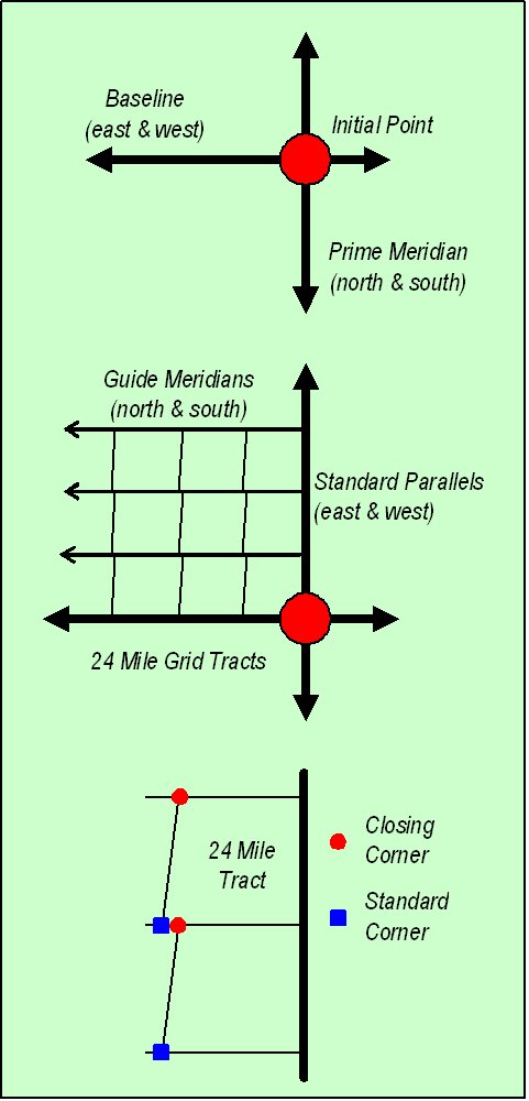
It all starts from an initial point, which is usually set by astronomical observation. In Michigan, the initial point lies about 12 miles north of Jackson, on the county line. There are about 30 initial points across the United States. From each initial point, a prime meridian extends north-south, and a baseline extends east-west.
Along the N-S prime meridian, points are marked at 24-mile intervals. From these points, standard parallels are extended east and west. Along each E-W standard parallel, points are also marked at 24-mile intervals, beginning from the N-S prime meridian. These points along the parallels are called standard corners.
From each standard corner, a line is run true
north (not magnetic north). These lines are called guide meridians.
Because of the Earth's curvature, these guide meridians do not
intersect the standard corners
along the next standard parallel, 24
miles to the north. These intersections are called closing corners.
So,
each standard parallel has a set of both standard
corners and closing corners.
At this stage, we have a 24-mile grid growing across the State of Michigan. Now, it's time to fill in the framework.
|
|
|
||
|
24
Mile Tract Divided |
|||
Each 24-mile tract is divided up into 16 townships. A township is roughly 6-miles by 6-miles. Beginning in the southeast corner of the 24-mile tract, corners six miles apart are established along the E-W standard parallel and the N-S meridians. From these corners, range lines are run true north to the next standard parallel, and township lines are run west to the next guide meridian. Note that the range lines converge in the north but the township lines remain parallel, always 6 miles apart.
Each township is now divided into 36 sections, a piece of land roughly one mile by one mile, or roughly 640 acres. The same process of establishing corners and running lines from the southeast corner of the township is used. Each section is then divided into 16 forties. These forties are further subdivided, and subdivided, and subdivided.
Township |
|||||
| 6 | 5 | 4 | 3 | 2 | 1 |
| 7 | 8 | 9 | 10 | 11 | 12 |
| 18 | 17 | 16 | 15 | 14 | 13 |
| 19 | 20 | 21 | 22 | 23 | 24 |
| 30 | 29 | 28 | 27 | 26 | 25 |
| 31 | 32 | 33 | 34 | 35 | 36 |
The last significant "wrinkle" about our Public Land Survey has to do with procedures when lakes were encountered. Usually, but not always, the "forties" around a lake are not true forties. Their boundaries adjacent to the lake follow the shoreline of the lake. The lake itself and the land under the water is typically owned by the public (administered by a government agency). If you see such a pattern in a plat book, then the lake is usually public water. Citizens are free to boat and fish on the lake, in accordance with any laws and regulations, assuming they can get to the lake without trespassing.
Land Survey Measurement Units
The language and terminology of land survey is new to most people. Our system dates back to old English units. The basic unit is an acre. An acre equals a square 208.7 feet by 208.7 feet, 43,560 square feet, 160 square rods, or 10 square chains (10 x 66' x 66'). An acre is about the same area as a football field, including the end zones.
There are 640 acres in a section, which is a single square mile, or one mile on each of four sides of a square, more or less any survey corrections made to the west and north tiers of a township. One mile equals 5,280 feet, 320 rods (16.5 feet), or 80 chains (66 feet). One chain is made from 100 links, each link being 7.92 inches long (792 inches / 100). Chains were used by early surveyors to mete out the lines they ran. They were actual chains made up of 100 links. The chain remains a standard unit in land survey, but rods are seldom used, except maybe among canoeists who measure portages in rods.
These rather odd measurements are rooted in Roman and English history.
The Roman "pertica" became the English "perch", "pole", "rood", and "rod". A pertica was a measuring stick. The "mile" came from the Roman "mille passum", which had something to do with the progress of Roman armies. There was a progression of imprecise definitions of measurement units over time. Queen Elizabeth (1533-1603) declared that a mile would consist of 8 furlongs, a furlong would be 40 poles (or rods), and a pole would be 16.5 feet (all this ends up with a mile of 5,280 feet). She apparently did not define a "foot". However, Koebel (1570) defined a "rood" (rod) as "length of exactly 16 of these shoes" from "sixteen men, short and tall, one after the other, as they came out of church".
The word "acre" was derived from the Roman "ager", which was defined as the area of land that a single yoke of oxen could plow in a single day. The "Star Chamber" during the time of Henry VII (1485-1509) declared that an acre would be an area 40 poles by 4 poles, or ten square chains, our current definition of an acre. Edmund Gunter (1581-1626) came up with a physical "chain" to measure land area. It was 66 feet long (4 rods). He tried to make it a bit "metric" by dividing the chain into 100 links (each 7.92 inches long).
No wonder most people have adopted the metric system!
 |
This website was developed and created by Michigan State University Extension for the teachers of the State of Michigan. |
Page Name:
TreeBasics/Survey.htm