Home Page |
MICHIGAN FORESTS FOREVER TEACHERS GUIDE
| FOREST OWNERSHIP AND RECREATION |  |
Owners of forest property dictate the nature and intensity of recreation opportunities on their land . . . more or less. Ownership objectives will vary widely. Public lands tend to place more emphasis on providing recreational activities than private lands because they generally adopt a more "multiple use" concept toward forest management. However, not all public lands have the same recreation objectives. Federally designated wilderness areas or Michigan Scientific Areas have restrictions. And although many privately-owned acres are open to public recreation, the opportunities are often restricted to hunting and fishing, on foot only. Other private ownerships, especially forestry corporations, tend to allow most forms of recreation as long as abuses do not occur. For more information on forest ownership in Michigan, visit the Forest Descriptors page.
There are a number of differfent public and private ownership categories. While the casual user might not have a need to acknowledge the differences, the differences produce variable opportunities for recreation. It is important for forest-users to appreciate recreation differences based on ownership and be certain to respect the wishes of the owner or managers of the forest.
![]()
National Forests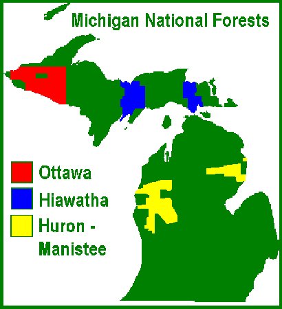 - 2,900,000
acres
- 2,900,000
acres
Ottawa
- Hiawatha -
Huron-Manistee
Forest Service National Website
Michigan contains three National Forests, the Ottawa (~1,000,000 acres), the Hiawatha (~880,000 acres), and the Huron-Manistee (~1,000,000 acres). The National Forests offer a wide variety of recreation. National Forests provide almost unlimited recreational opportunities, from camping (free) allowed nearly anywhere on the forest to developed and handicapped-accessible facilities (fees required). The National Forests have over 75 campground units, miles of rivers, hiking trails, snowmobile trails, many inland lakes, cabin rentals, and many waterfalls.
Wilderness Areas are special categories of federal land. They are created by Act of Congress and have specific meanings and restrictions. In Michigan, there are ten national forest wilderness areas, three on the Ottawa, six on the Hiawatha, and one on the Huron-Manistee. These designated areas cover about 91,000 acres. However, you don't always need a formal Wilderness Area to experience the qualities of wildness. There are nearly three million acres of "wild" country on National Forests and millions more on other ownerships.
The three forests host around eight million recreation visits each year. Michigan National Forests are within an eight-hour drive of major metropolitan areas of Minneapolis-St. Paul, Chicago, Milwaukee, and Detroit. That means fairly easy vacation access for about 25 million people!
Like most public lands, the creation of the National Forests was piecemeal through a variety of Congressional Acts. Much of the land reverted from tax delinquent properties in the 1920s and 1930s. It is important to remember the history of our national and other public forests. For the most part, they started out as cut-over, burned, and abused lands. Natural recovery and decades of forest management have created the landscapes we enjoy today. Visit the Michigan Forest History pages for more information.
The U.S. Forest Service is part of the U.S. Department of Agriculture and has three main branches. The National Forest System is the most well-known. The other two branches are State and Private Forestry and Research Centers. National Parks and National Wildlife Refuges are NOT part of the Forest Service.
![]()
National Parks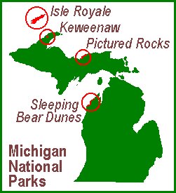 - 630,000
acres
- 630,000
acres
National Parks are managed almost exclusively for low intensity recreation and wilderness values, based on special features in the landscape. Many restrictions are usually in effect in National Parks and resource management activities are minimized or prohibited by management plans. Michigan has four park units; Isle Royale National Park, Pictured Rocks National Lakeshore, Sleeping Bear Dunes National Lakeshore, and Keweenaw National Historic Park.
The parks receive about two million visits each year. Most of the visits are at Sleeping Bear Dunes. Isle Royale receives the fewest visits, mostly due to it's remote location off the shore of Ontario. Keweenaw National Historic Park is a new addition, designated in 1992.
The National Lakeshores contain some of Michigan's most dramatic Great Lakes scenery, but also have terrific inland features as well. There are only four National Lakeshores in the United States, all on the Great Lakes. Sleeping Bear Dunes (57,000 acres) "was established primarily for its outstanding natural features, including forests, beaches, dune formations, and ancient glacial phenomena. The Lakeshore also contains many cultural features including a 1871 lighthouse, three former Life-Saving Service/Coast Guard Stations and an extensive rural historic farm district." Pictured Rocks (35,725 acres) features "multicolored sandstone cliffs, beaches, sand dunes, waterfalls, inland lakes, wildlife and the forest of Lake Superior shoreline. Attractions include a lighthouse and former Coast Guard life-saving stations along with old farmsteads and orchards. At its widest point the Lakeshore is only five miles and hugs the Superior shoreline for more than 40 miles."
Isle Royale (539,300 acres) offers spectacular scenery, a world-renowned long-term moose-wolf study, and uncommon plant associations and rare species. It is, by far, Michigan's largest National Park Service unit. "There is excellent fishing, historic lighthouses and shipwrecks, ancient copper mining sites, and plenty of spots to observe wildlife. Roadless Isle Royale is accessible only by boat or float plane. Isle Royale is relatively untouched by direct outside influences and serves as a living laboratory and Unites States Biosphere Reserve." However, Isle Royale used to be a commercial fishing center and was mined for copper. Much of the island was burned over in a horrendous 1936 wildfire. The Civilian Conservation Corps fought the fire and later built many facilities in the 1930s.
Keweenaw Historic Park has almost no acreage but seeks to maintain cultural resources from the historic copper mining era, which goes back 7,000 years. "The Keweenaw Peninsula was the site of America's first large scale hard-rock industrial mining operations. The copper mines of the Keweenaw were critical to the industrial development of the United States. Mine shafts here reached over 9,000 feet deep. The men who labored, and sometimes died in these mines, along with the women who nurtured them, gave the Keweenaw Peninsula a rich mix of language, costume, and custom."
The National Park Service is part of the U.S. Department of the Interior and includes parks, lakeshores, trails, monuments, historic sites. It is NOT part of the Forest Service, which is in the U.S. Department of Agriculture.
![]()
National Wildlife Refuges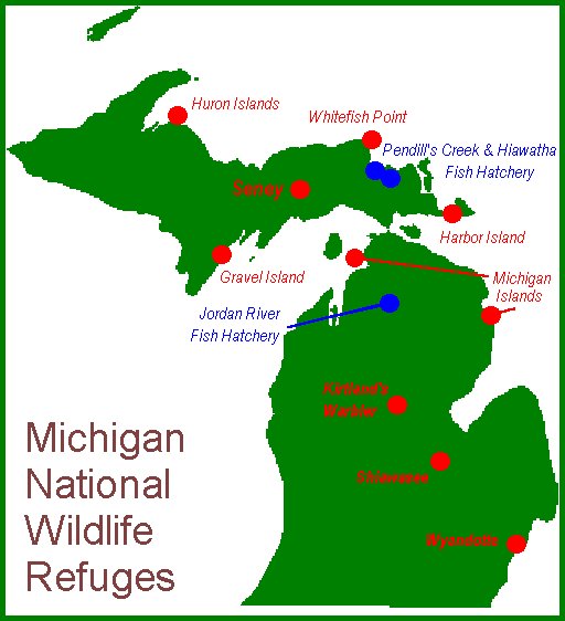 - 114,000
acres
- 114,000
acres
The U.S. Fish and Wildlife Service manages the national network of wildlife refuges and performs other functions. Recreation opportunities on national refuges are sometimes limited by regulations designed to protect sensitive areas or certain wildlife species. However, on other refuges, a wide variety of activities are permitted, including hunting, fishing, boating, etc. Of course, the main attraction would be wildlife viewing! These properties host 145,000 visitors each year.
Most of Michigan's national wildlife refuges are small. The largest refuge is the 95,000 acre Seney Unit, located in the central U.P. Other large refuges are the Shiawasee (9300 acres) near Saginaw, and the Kirtland's Warbler (6500 acres) in the central Lower Peninsula.
The Fish and Wildlife Service are part of the U.S. Department of Interior, the same as the National Park Service.
![]()
State Lands - 4,150,000 acres
State Forests
The State of Michigan owns about four million acres of land and has the largest State Forest System in the lower 48 states (Alaska has the largest). The State Forests experience about 18 million visits each year. There are six state forest units;
While our State Forests are important to Michigan for many reasons, recreation is probably the first use that comes to mind for most people. Most campgrounds are rustic (pit toilets and hand pumps), in contrast to the more developed facilities at State Parks and on National Forests. State Forests have 145 campgrounds with nearly 3,000 campsites. Additionally, there are 880 miles of hiking trails, 240 miles of ski trails, 6,000 miles of snowmobile trails, 7,000 miles of canoe routes, 500 miles of Great Lakes shoreline, 600 miles along inland lakes & river, and over 3,000 miles of ORV trails. The 8,000 miles of forest roads offer many opportunities for mountain-bikers, horseback riders, back-country drives, ungroomed snowmobiling, and other activities.
Like all campgrounds, there are overnight fees, and vehicles require Recreation Passports. Similar to the National Forests, camping is permitted for free anywhere on the State Forests, except for campgrounds and other special use areas.
State Forests are not the same as National Forests, although they will look pretty much the same to most visitors and offer similar recreational opportunities. However, the different ownerships result in different management emphases, although both public forest systems practice multiple-use management. State Forests are owned by the citizens of Michigan and are managed by the Michigan Department of Natural Resources. National Forests are owned by citizens of the United States and are managed by U.S. Forest Service, headquartered from Washington, D.C.
State Parks
96 State Parks and Recreation Areas are located throughout Michigan covering over 250,000 acres. Parks feature special places in our landscape and celebrate our history and culture. State Parks are host to over 20 million visitors and campers each year, making them some of the most heavily-used recreation areas in Michigan.
The two largest State Parks are located in the Upper Peninsula. The Porcupine Mountains have 60,000 acres and Tahquamenon Falls has 40,000 acres. Both parks offer outstanding physical characteristics, including Michigan's largest waterfall. State Parks hold 115 miles of Great Lakes frontage and over 200 miles along inland lakes and rivers. There are over 14,000 campsites. Michigan's first state park was on Mackinac Island, established in 1895.
State Parks have many of the opportunities expected, such as camping, picnicking, hiking, biking, snowmobiling, skiing, and fishing. Hunting is allowed in many State Parks, but often only at certain times, for certain species, and with certain weapons. Most facilities include showers, flush toilets, electrical hook-ups, RV sanitary stations, and playgrounds. Some State Parks also offer rental cabins, wilderness areas (not federal wilderness), old growth, historical re-enactments, old forts, downhill skiing, wheelchair access, Artesian wells and large spring-fed pools, interpretive programs, special ORV (off-road vehicles) areas, and other lesser-known activities.
Vehicles are required to purchase an entry sticker and campgrounds have overnight fees. In some parks, picnic shelters can be rented and reserved. For information about particular parks, try the DNR website.
![]()
Local Government Forests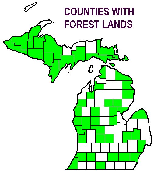 - 260,000 acres
Local governments in over half the counties in Michigan own forestland. These forests are owned by the residents of a county, township, or city and are generally managed according to the wishes of the local residents. The forests are administered by different boards, councils, and commissions and not all are interested in natural resources.
Recreation occupies a prominent role in some sets of management objectives, although some rural counties know that timber management can provide significant revenue on a sustainable basis. Other counties own forestland for non-forest uses such as gravel pit expansion, future county building construction, landfill sites, housing developments, etc.
Michigan's largest county forest (50,000 acres) is located in Gogebic County, at the far west end of the Upper Peninsula. The second largest forest (9,300 acres) is located in Marquette County. Both are actively managed, as are most larger forests. Most county or municipal ownerships are much smaller.
County forests offer many of the same recreational opportunities as other public forests, but they are often underutilized. On the other hand, some of the county/municipal forests and parks receive high levels of use, especially day-only activities.
Compared to Wisconsin and Minnesota, our county forests are a small piece of the landscape. Most of the Michigan tax delinquent lands in the 1920s and 1930s ended up in state or federal government. In Wisconsin and Minnesota, much these lands ended up in county ownership, with over two million acres in each state.
![]()
Commercial Forests - 3,500,000
acres
- 3,500,000
acres
The Michigan legislature offers tax reduction to private forestowners willing to manage their forest for timber production and allow public hunting and fishing. Over two million acres of forest are enrolled in this Commercial Forest Program, mostly corporate ownership. Michigan's largest enrollees are Weyerhaeuser, The ForestLand Group, GMO, and other "TIMOs" and "REITs", which are investment companies. The program is administered by the DNR.
Enrolled lands are open to hunting and fishing, but only foot access is guaranteed under the rules. The public does not have a "right" to drive ATVs, trucks, or cars onto CFP tax lands, although this is often permitted by the forestowners. Gates are legally erected in any areas where vehicle access is not wanted.
Other forest recreation activities are also allowed by the landowners, but these are not guaranteed under the tax program. As a matter of courtesy and a point of information, it is always a good idea to check with the owner before using a property. Sometimes, maps are made available to forest users. Not ALL corporate forest is listed under the tax program. It's a good idea to make sure the land you wish to use is open to the public and what is permitted when it is open. On-line maps are provided by the DNR
Michigan has a second forest tax law called the Qualified Forest Property program, administered by the Department of Agriculture and Rural Development. Enrollees tend to be smaller ownerships who wish to post their forestland. The tax reductions are not as large as the Commercial Forest Program. The acreage has been increasing for a decade, but as of the middle of 2019, there were XXX acres enrolled in the program.
![]()
Private Non-industrial Forest - 8,500,000 acres
This category of land (PNIF) makes up about 45 percent of Michigan's timberland! These owners are the Moms and Pops, hunting clubs, partnerships, and the like. Access to most of these lands is not open to the public and property is often posted against trespassing. However, PNIF owners will often permit trails to cross their property and there are many privately-owned campgrounds, RV parks, and natural attractions. Some PNIF land is enrolled in Michigan's Commercial Forest or Qualified Forest programs.
PNIF ownership is more concentrated in the Lower Peninsula, making up 59 percent of the timberland, with only 26 percent of the Upper Peninsula timberland. The U.P. has large proportions of both industry-owned forest AND public forest (a very unusual arrangement in the USA). Menominee County (U.P.) has the largest PNIF acreage in Michigan, although it is only 58 percent of the timberland. Bay and Hillsdale Counties have fairly small acreages, but are nearly entirely privately-owned. This trend reflects ownership differences from north to south.
In 2006, a new forest management incentive program was introduced to Michigan. The Qualified Forest Property program exempts eligible forest property from local school taxes, usually 18 mils in rural areas. The rules for eligibility are similar to the Commercial Forest program but enrolled forest lands do not need to be made open to the public. For many private forestowners, this is an important feature of the QFP program.
 |
This website was developed and created by Michigan State University Extension for the teachers of the State of Michigan. |